Land use and soil
Access to land is essential to raw materials production, especially to establish extractive activities where deposits can be exploited. Fostering the sustainable supply of raw materials from EU sources, including granting access to land, is the aim of the second pillar of the EU Raw Materials Initiative (RMI).
At the same time, the management of the impacts derived from land uptake and land use associated to raw materials production is one of the key environmental challenges of the sector. The sector’s land uptake often involves competition with other possible uses of the land. It can also lead to soil loss and degradation, with the subsequent deterioration of soil functions (ecosystems support, agricultural production, water retention, carbon sequestration, etc.).
While both extractive and manufacturing activities can lead to impacts on land and soil, impacts from extractives industries are usually more severe. Extractive industries’ impact on land starts with the prospection of mineral occurrences and continues even after mine closure. In fact, impacts on land from abandoned mines can be large. Reclamation activities can partly mitigate these impacts. However, reclamation often does not take place in optimum conditions. Indeed, legacy mines are considered among the main concerns related to the environmental impacts of mining worldwide (Dolega et al., 2016).
In most European countries the management of mining activities is connected to land use planning, under conditions that largely vary across countries. While in some regions/countries mines are protected or designated as mining areas, other countries’ regulations consider only the use of the land for mining when there is a permitting request (Minatura Deliverable 3.1, 2016).
Land uptake
Land uptake by mining starts with the prospection of mineral occurrences, which may require access to a large area of land (sometimes tens of square kilometres) (COM(2000)265). Land uptake continues with the operation of the facility and upon the expansion of the mine. The uptake of new land stops with mine closure. The level of invasiveness of the exploration techniques depends on whether existing roads and infrastructure are used or new ones need to be developed for e.g. exploratory drilling (ICMM, 2011). These activities can create new openings in areas that were not so accessible previously for other uses of the land such as logging or agriculture. Therefore, they can indirectly lead to further occupation of the surrounding land (ICMM, 2011). Invasiveness depends also on the type of deposit. For instance, exploration for metallic minerals and high quality industrial minerals can demand broad areas of land (COM(2000)265).
After exploration, exploitation itself requires a more limited land area, usually measuring a few hectares (COM(2000)265). However, impacts from land uptake are more intense, including clearing of vegetation, building of the site facilities and infrastructure (roads, pipelines and electricity lines), etc. Different mining typologies can have very different land footprints (Spitzley et al., 2008). Large-scale open pit mining can be responsible for most of the destruction of agricultural land and ecosystems while underground mining typically has a relatively small land footprint associated (ICMM, 2011). Open pits tend also to deepen and widen progressively, but can also offer more possibilities for progressive rehabilitation (ICMM, 2011). Similarly to exploration activities, land uptake during exploitation can also indirectly lead to further land uptake by other uses that can benefit from the infrastructure created (ICMM, 2011). This can also include human settlements where new workers may establish.
Once mining finishes, rehabilitation activities, also referred as reclamation, are to be put in place to return the disturbed land to a stable and productive condition (ICMM, 2019) (see section below on mine closure and rehabilitation).
Land competition
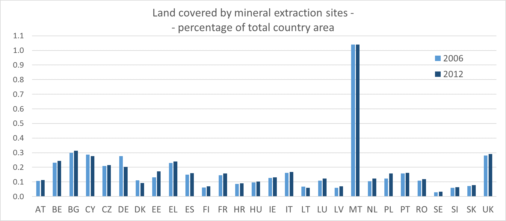
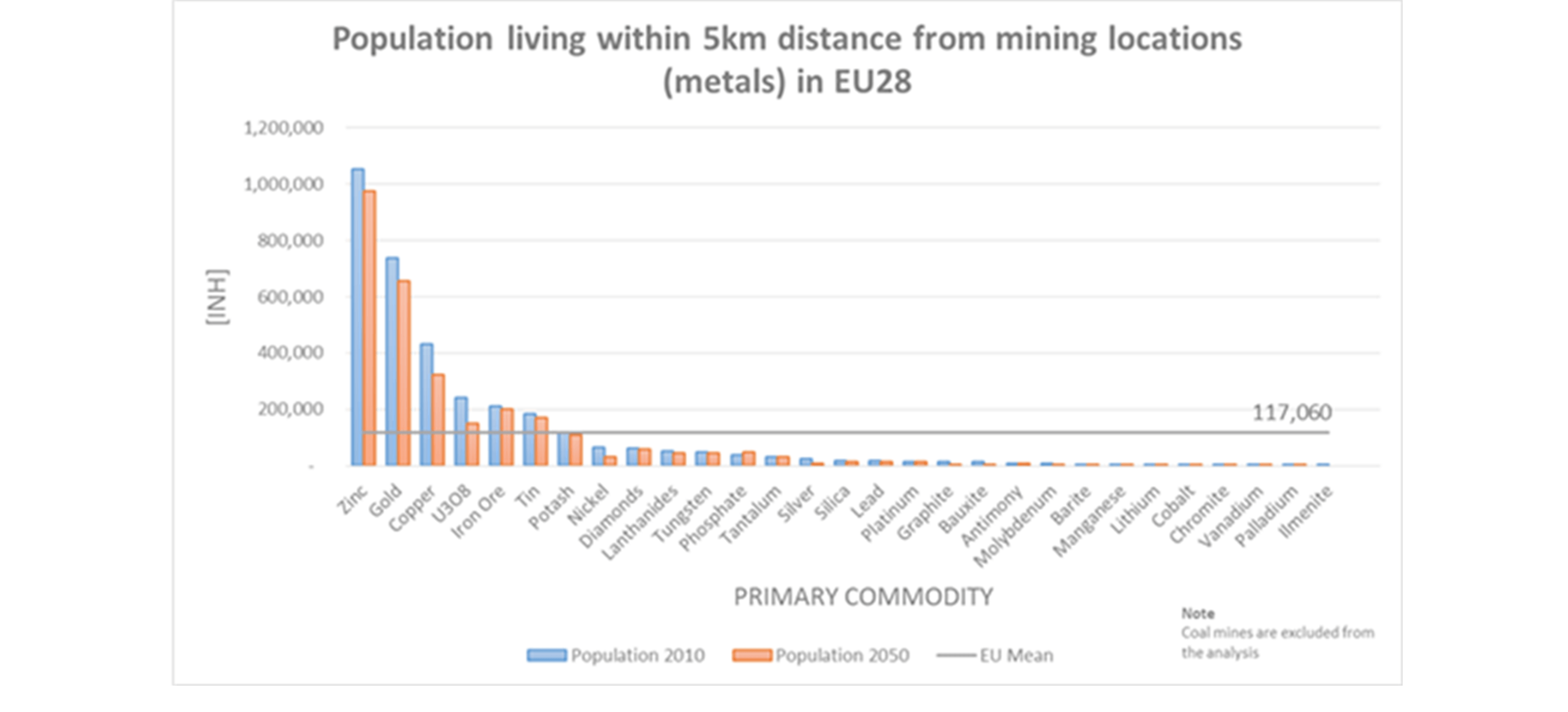
Compared to other activities, such as agriculture, mining activities have a relatively small demand for land – 0.15% of total area in 2012 (average for the whole EU, see Figure 1 for a breakdown of the data by country). Mining activities can be perceived as positive since it can create income and jobs, and synergies with other manufacturing activities in the region. However, competition for land can also have relevant negative impacts at the local level, compromising the ability of local land to meet other needs (agricultural production, tourism, housing, etc.). This might also lead to problems for the mining activity itself, which may face problems obtaining the Social License to Operate.
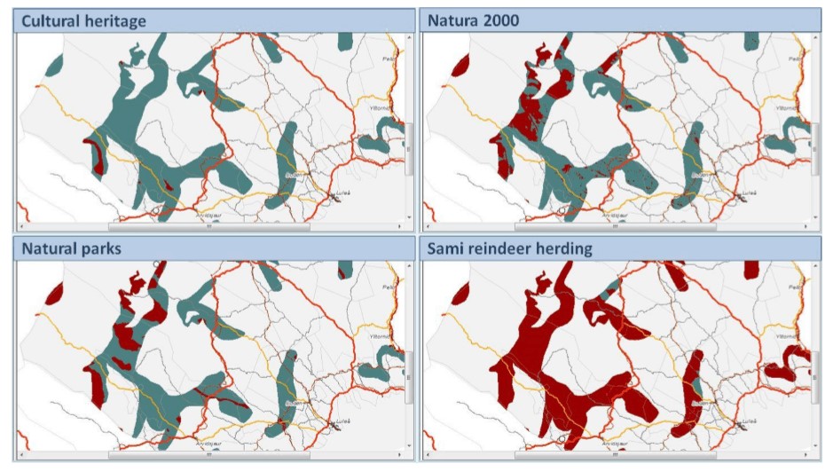
Limitations to mine permitting may be linked to the protection of environmental, social or economic assets: from nature protection to the protection of water resources, cultural heritage and/or infrastructure (Figure 2).
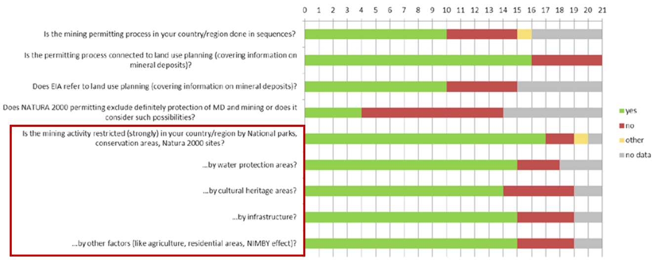
Three typical land uses that can compete for land with extractive activities are nature protection areas, agricultural land and human settlements. Among these three, the existence of nature conservation areas is the main factor restricting mining activity (Minatura Deliverable 3.1, 2016). Nature protected areas in the EU include the Natural 2000 network and the Nationally Designated Areas. Possible restrictions to the development of extractive activities in these areas depend on the level of protection, where permits can be still granted under specific conditions.
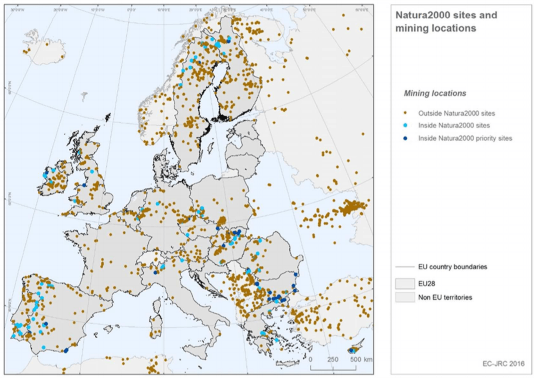
Currently, many mining sites are located within a Natura 2000 site (around 10% according to 2016 data). Indeed, a relevant share of mineral deposits are located within a Natura 2000 site (Figure 3). This situation was highlighted as a possible influence to raw materials’ supply risk in the study to support the 2014 list of critical raw materials. However, the biggest share of sites falling into Natura 2000 areas are actually not operating anymore (abandoned or exhausted). These data refers to both producing mines and not operational mines. This situation highlights the fact that often extraction is compatible with conservation on the one hand. On the other hand, it highlights that production in many areas shall undergo the limitations established by nature conservation objectives. Obtaining a mining permit within Natura 2000, although not impossible, usually involves restrictions and a complicated procedure (Minatura Deliverable 3.1, 2016). Moreover, almost 30% of the mining sites located within Natura 2000 fall within the boundaries of a protected area classified as ‘priority site’, which implies that regulation and criteria applied for permitting human activities are more stringent (according to the Habitats directive and the Birds directive). In addition, around 70% of mining locations (again based on 2016 data) are in close proximity (within a 5 km radius) of these natural protected areas, which might limit the expansion of the mine.
On an EU scale, the Minatura project has analysed the location of the main mineral deposits and its possible competition with other current land uses and future demands for land (Figure 4). Considering also forecasts of materials demands, the project has identified a set of potential protected areas that suit a set of selected safeguarding criteria in selected case study countries. The European Commission has also edited guidelines on extraction to provide clarity on how to reconcile extractive activities in or near Natura 2000 are also available.
Beyond protected areas within the EU, the study by Murguia et al. (2016) considers all ecosystems worldwide and shows that mines and deposits are not randomly located but concentrated in intermediate and high (plant) diversity zones.
Regarding competition for land in the vicinities of urban settlements (Figure 5) and agricultural land, specific regulations, usually at regional and/or local level, may restrict the development of extractive activities. In such cases, in addition to the possible legal restrictions, uses such as agriculture or urbanization might be more profitable or sufficiently profitable while socially more accepted than extractive activities. However, mining activities can be also perceived as positive, especially in areas with limited income sources - a mine creates jobs and therefore attracts people -, or in areas where mining can establish synergies with other manufacturing activities in the region.
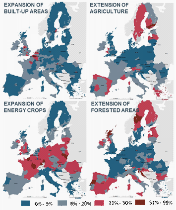
In the future, both urban and agricultural areas are expected to expand in the coming years in the EU. This is also the case of other uses, such as energy crops and forest areas (Figure 6).
Soils provide essential support to ecological and human systems, and have been under pressure due to the intensification and expansion of human activities. In fact, the majority of the world's soils are in fair, poor, or very poor conditions (FAO, 2015).
Extractive activities can lead to soil loss, to mechanical degradation due to e.g. compaction, and to soil contamination, with the subsequent temporary or permanent damage to soil functions. In addition, modifications of the land spatial pattern can also have relevant impacts on the connectivity of ecosystems, which is often key to safeguard nature. While soil contamination can be improved with remediation measures, damages such as soil compaction are nearly irreversible (Bide et al., 2019). The type of mining and processing practices, and the features of the soils, will determine the extent to which soil can be impacted by mining activities.
Impacts on soils can be much more critical and difficult to quantify in the case of accidents such as tailing dam failures, which still occur under certain circumstances. Tailings dam failures are among the events with higher environmental impacts (Dolega et al., 2016). Indeed, after the tailings dam failures in Aznalcóllar (Spain) and Baia Mare (Romania) in 1998 and 2000, mining’s environmental impact gained attention in EU environmental policy and resulted in the Mining Waste Directive regulating new mines in 2006 (Dolega et al., 2016) and linked to that, the update of the BAT Reference Document for the Management of Waste from Extractive Industries (2018).
The European thematic strategy for soil protection identifies as main threats to soils in the EU some of the pressures coming from the extractive sector (e.g. erosion, compaction and sealing). The proposal for a Soil Framework Directive from the European Commission aimed to establish a common, harmonised approach for the protection and sustainable use of soils in Europe. However, the proposal was pending for several years and ultimately withdrawn.
Individual EU countries have national legislations about soil conservation, but the majority of EU countries are just starting to introduce basic regulations on the topic (Bide et al., 2019). Several national approaches establish indicators and threshold values for pollutant concentration, depending on the use of the land. Other countries establish values for point pollution (Bide et al., 2019).
Soil loss and mechanical degradation
Mining practices lead to soil loss and mechanical degradation due to sealing and compaction, which generally are irreversible. Soils can be directly removed, which causes soil loss by deforestation: surface mining removes vegetation and soil on the surface, and underground mining involves digging and tunnelling to reach deep mineral deposits (Bide et al., 2019). The establishment of infrastructure causes soil sealing. Further, the use of heavy machinery causes soil compaction, as well as the leave of pits and heaps of waste material from underground and surface mining. The loss of macro porosity and pore continuity reduces the ability of the soil to conduct water and air, and subsequently, reduces soil fertility (Bide et al., 2019).
In addition, erosion by wind and water can be accentuated by mining activities that can reduce soil particle size such as crushing and milling (Dolega et al., 2016).
Soil contamination
During mining and processing, pollutants coming from the deposit mined itself as well as from the chemicals used for the extraction and onsite processing are emitted and can be leached to soils. Spills, and leaks of hazardous materials, and deposition of contaminated dust can lead to soil contamination (Bide et al., 2019). Pollutants can include heavy metals, saline chemicals, etc., which can degrade the quality of the soil. The use of different mining techniques and chemicals (e.g. cyanides) can have differential impacts on soil quality (Dolega et al., 2016). Pollutants may also originate from fuel combustion and from specific industrial process, for instance metal smelting or casting. The presence of heavy metals in soils is a matter of particular concern because of their toxicity to humans and their persistence in the environment (Bide et al., 2019).
Acid mine drainage (AMD) can have extensive impacts on soil and water. AMD occurs when sulphide minerals react with oxygen and water, leading to the formation of sulphuric acid forms, which can dissolve e.g. heavy metals. In addition, chemicals used for processing such as cyanide or nitrogen-compounds, ore elements and tailings sludge can further contaminate soils and water (Dolega et al., 2016). The joint action of erosion, chemical leaks and AMD can have even more devastating effects (Dolega et al., 2016).
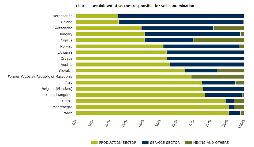
Mining and mineral processing operations are often the most serious local sources of soil contamination by metals and metalloids. Together with metal industries, mining is frequently reported to be an important source of contamination, particularly in some countries (van Liedekerke et al., 2014, Payá Pérez and Rodríguez Eugenio, 2018) (Figure 7). In addition, soil contamination frequently leads to contamination of associated water bodies, since pollutants can percolate into groundwater or reach surface water bodies (Payá Pérez and Rodríguez Eugenio, 2018).
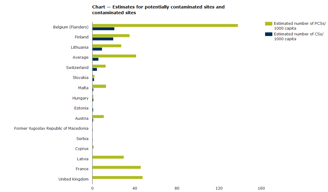
Nowadays, there is a high number of sites that are classified as contaminated or potentially contaminated (Figure 8). Payá Pérez and Rodríguez Eugenio (2018) provide a comprehensive overview of the status of identification and characterization of contaminated sites across the EU - they highlight that, in some countries, a mapping of these sites is still lacking. The study provides data on the progress towards remediation of contaminates sites and the EU and national (sometimes sub-national) policy and regulation framework related to that. This includes also considerations on how to deal with historic contamination and ‘orphan’ sites, i.e. those sites where the polluter-pays principle cannot be applied since the polluter either has gone or is not financially able to support the intervention cost. The study states that criteria for addressing historical contamination vary across countries (and even within the same country) and are often laxer than criteria for new polluting activities.
Soil contamination from extractive waste
Diffuse emissions to soil and groundwater usually derive from extractive waste management activities, which includes waste generated from mineral excavation, mineral treatment and waste preparation for re-use and recycling (Best Available Techniques (BAT) Reference Document for the Management of Waste from Extractive Industries, 2018). The rate of diffuse emissions depends on the waste characteristics, the water head, the basal structure, being the construction quality control and quality assurance systems essential (BAT Reference Document for the Management of Waste from Extractive Industries, 2018). The BAT Reference Document for the Management of Waste from Extractive Industries provides indications about the main environmental concerns linked to extractive waste management (main pollutants, dangerous pollutants). It describes processes for a better handling of the waste along their processing stages. It provides also considerations for normal operation conditions, indications to improve the safety of the facility, and on how to operate in emergency conditions.
There is a substantial gap in consistent information on European level on how mining wastes in EU Member States and Candidate Countries are managed, what their major hazards are and where the sites generating the greatest hazards are located, including abandoned mines (Bide et al., 2019).
Impacts on land can be extensive after the closure of an extractive activity. Therefore, once the mining activity is ceased, mining companies are responsible for land rehabilitation (also called reclamation), i.e. the return of disturbed land to a stable and productive condition (ICMM, 2019).
The level of rehabilitation that is possible varies from site to site. Returning the land to the pre-mining land use is not always possible, due to alterations of the socioeconomic context and the landscape, but should be evaluated. A wide variety of alternative uses for mined lands is available: post-closure landscapes adapted for forestry, agriculture, wildlife conservation or recreational areas.
In any case, there should be a clear plan for transitioning from operational to closure and decommissioning and, ultimately, post-closure (ICMM, 2019). For some mines, this phase may last longer than its operational life. Closure activities can be carried out also during the operation of the activity, which is known as progressive closure. Indeed, optimally, the planning of mine reclamation should occur before the mining permit is granted.
Closure works should include (see Table 1) engineering works, administrative works (e.g. transferring assets, demobilising the labour force, relinquishing agreements with governments and/or NGOs). It should also include due diligence monitoring and reporting on the post-decommissioning status of environmental and social aspects of the site (ICMM, 2019).
Table 1. Some of the most common progressive closure works.
|
Closure works |
|
• Soil management (e.g. stripping, stockpiling, placement). • Strategic placement of uneconomic materials • Diversion of unimpacted waters • Revegetation • Stabilisation works • Cover placement • Demolition of unneeded infrastructure • Improvements to water management infrastructure • In-pit dumping of waste rock material • Capping or encapsulation of tailings waste rock material |
Source: Adapted from ICMM (2019), Integrated Mine Closure - Good Practice Guide.
Ecological restoration and mine reclamation have become important parts of the sustainable development strategy in many countries. The International Council on Mining & Metals (ICMM) has elaborated a good practice guide for Integrated Mine Closure, which provides guidance on integrated closure planning, and includes successful examples and tools. Several national mining closure plans and recommended guidelines exits such as the Finish Mine Closure Handbook and Swedish Guidelines. Several European countries have monitoring programmes on national level (Bide et al., 2019).
So far, modernization of information technologies has made it possible to set up more efficient systems of environmental monitoring, and real-time monitoring. However, abandoned mines and mines whose activity is based on old operations, which may not have worked according to modern environmental standards and which may lack environmental management plans, constitute the highest environmental risks of mining (Bide et al., 2019).
Europe has a huge legacy of abandoned mines; some abandoned mine sites and tailings ponds can still be found even close to residential areas (Dolega et al., 2016). This legacy was already highlighted by the COM(2000)265, which pointed to the existence of a legacy of abandoned mine sites and unrestored quarries in the EU, result of unsatisfactory environmental performance of the industry in the past, which impact the landscape and can pose severe environmental threats due especially to acid mine drainage.
Outside the EU, although current discussions on raw materials governance focus on active mines, environmental challenges from lack of remediation and legacy mine sites seem to be massive in many countries (e.g. in South Africa, Chile, Peru and Sub-Saharan countries) (Schueler et al., 2018). This refers to both Artisanal and small-scale (ASM) and to large-scale sites, with the exception of some mines from which secondary materials are recovered from old tailings (Schueler et al., 2018). Sites under ASM practices, responsible for 15-20% of global mineral and metal production, are generally characterized by poor environmental management and very limited or absent reclamation or soil remediation, and impacts on land are more scattered in the territory than for regular mining.
A proper land use planning, from the start of the project until its closure, can help to mitigate environmental pressures on the land, and also reduce risks of negative impacts on soils, water, nature, climate, etc. (ICMM, 2011). This may also improve the relationship with the local communities. Table 2 suggests approaches to an improved land use planning for the different stages of mining.
Table 2. Approaches to reduce mining environmental impacts on the land.
|
Stage |
Approach to reduce impacts on the land |
|
Exploration |
The use of technologies in exploration such as remote sensing or satellite imagery can reduce the need for invasive exploratory techniques; planning exploration around existing infrastructure can reduce the impact of roads on the forest |
|
Activity (set up and expansion) |
Environmental management systems and careful decision-making on infrastructure placement and mining area design. |
|
Closure |
As a mining operation approaches the end of its life, there should be a clear plan for transitioning from operational to closure and decommissioning and, ultimately, post-closure. This should optimally include: •Engineering works to decommission and dismantle infrastructure, complete rehabilitation, grade landforms for effective drainage, cap and cover tailings facilities, implement post-closure monitoring networks •Administrative works relating to transferring assets, demobilising the labour force, relinquishing agreements, and other government and NGO agreements •Due diligence monitoring and reporting on the post-decommissioning status of environmental and social aspects of the site. |
Source: JRC elaboration based on ICMM (2011), and ICMM (2019).
DG GROWTH provides also guidance on best practices in the area of land use planning and administrative conditions for exploration and extraction. This document gives an overview on regulatory framework for mining and explains specific case studies where e.g. land competition issues have arisen.
Mineral extraction sites and deposits
Spatial data on the location of mining activities and mineral deposits is available from different sources. The Geological Surveys of Europe (EuroGeoSurveys), within the Minerals4EU project, compiled this type of data in a systematic way and provides a map viewer where mines and mineral occurrences, among other information types, are displayed (see Figure 9). This map viewer provides also the location of mineral occurrences, which can be filtered by categories such as base metals, precious metals, critical metals, etc. Although the project attempted to build a comprehensive database of mineral extraction sites across Europe, significant data gaps exist for some countries.
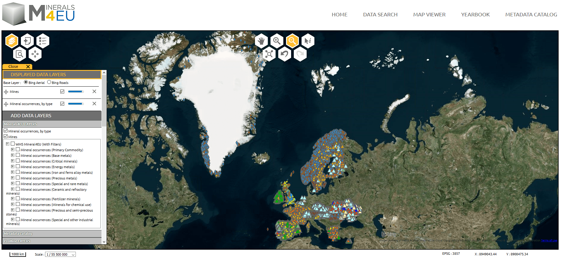
In addition, the viewer for the results of the Mintell4EU project, within the GeoERA action, also displays spatial data on mineral occurrences and mines. It also displayed background geological maps. Moreover, this portal allows the user to import the spatial data (both vector and raster layers).
At national level, many geological surveys collect and make publically available data for active mineral extraction. Table 3 gives an overview of geological survey data portals with information on the locations of mining and quarrying. However, these datasets are not harmonised across EU countries. These sources often do not capture small quarries, since they may be subject to different planning laws. For instance, publically available data in Finland only includes large mines, while small mineral operations are not registered (Bide et al., 2019).
Table 3. European geological surveys with data portals containing information on the location of mines and quarries.
|
Country |
Geological map portal |
|
Croatia |
http://www.hgi-cgs.hr/images/geoloska-karta-republike-hrvatske-1-300.jpg |
|
Czech Republic |
|
|
Denmark |
https://eng.geus.dk/products-services-facilities/data-and-maps/maps-of-denmark/
|
|
Finland |
https://www.gtk.fi/en/services/data-sets-and-online-services-geo-fi/map-services/ |
|
France |
|
|
Germany |
|
|
Ireland |
|
|
Norway |
|
|
Poland |
http://geologia.pgi.gov.pl/arcgis/apps/MapSeries/index.html?appid=8d14826a895641e2be10385ef3005b3c |
|
Romania |
|
|
Slovakia |
|
|
Spain |
|
|
Sweden |
Source: Updated from Bide et al. (2019).
At the global level, SNL Metals & Mining provides, under licence, data on the location of mining activities and their production capacity, classified by main commodity and by mining stage. There are some initiatives, e.g. Cadaster Map Portals, which provide detailed cadaster data for some non-EU countries.
Land cover and land use
CORINE land cover provides maps of a mixture of land use and land cover data, derived from the Copernicus network of earth observation satellites and in-situ sensors. It includes a category for mineral extraction sites as one of the 44 classes that the dataset covers. However, this land class does not distinguish between the mining of different commodities. CORINE land cover is regularly updated, with data for 1990, 2000, 2006, and 2012, and 2018. Land cover/use changes between 2006 and 2012 are available here, and changes between 2012 and 2018 here.
Information on land cover/use from mining activities other than that coming from remote sensing is usually available at a local/regional planning level, yet harmonization of this data at EU level lacks.
The Land Use and Coverage Area frame Survey (LUCAS) gives an EU wide breakdown of changes in patterns of land use. This survey is based on topsoil sampling on the ground, with points spaced 2 km apart covering the whole of the EU’s territory (1.1 million different points), followed by statistical calculations that interpret observations in the field to derive full coverage land use data. LUCAS includes mining and quarrying as one of the land use/cover categories. However, LUCAS is more meant to monitor the effect of land management of soil characteristics (see section below on data on soils) than land use as such.
Other land cover data sources with a global coverage, such as the Copernicus Global Land Service, do not distinguish mineral extraction sites as a land use/cover category.
Soils and contaminates sites
The European Soil Data Centre (ESDAC) is the thematic centre for soil related data in Europe. It provides comprehensive data, maps and atlas on soil types, and soil properties and functions. It also publishes data on the vulnerability of soils to main threats such as compaction, contamination and sealing. It also provides point data coming from e.g. the topsoil LUCAS survey (see description below). The ESDAC Map Viewer allows to navigate many of these key soil data.
A dedicated section provides information about concentration of copper on top soils. In addition, the sections on regional data and global data, links to soil datasets that can potentially be accessed and/or downloaded.
Hosted also within ESDAC, the LUCAS samples topsoil properties across the EU with points spaced 2 km apart covering the whole of the EU’s territory (1.1 million different points). It is meant to monitor soil properties and how they are affected by different drivers such as management practices. LUCAS results are hosted by Eurostat. In addition, the European Environment Agency (EEA) hosts a LUCAS data viewer, showing also ground-level pictures. The LUCAS 2015 soil survey targeted physicochemical properties, including pH, organic carbon, nutrient concentrations and cation exchange capacity.
Within the section on soil contamination, the ESDAC publishes data related to the indicator for monitoring the progress in management of contaminated sites. Data cover contaminated sites and progress towards their remediation. This indicator is within the dataset used by the EEA to monitor the state of the environment in the EU, and it is based on official soil data provided by EU countries (and beyond) from the European Environment Information and Observation Network. An important share of contaminated sites are indeed mining sites, especially for some countries. The dataset shows some issues related to the heterogeneous interpretation of the concept ‘contaminated site’ across countries, and large uncertainties in terms of methodologies and data. There is a gap in industry specific data or data related to ground conditions, which hampers the possibility to work out causes of any contamination and soil degradation (Bide et al., 2019).
Nature protection areas and biodiversity
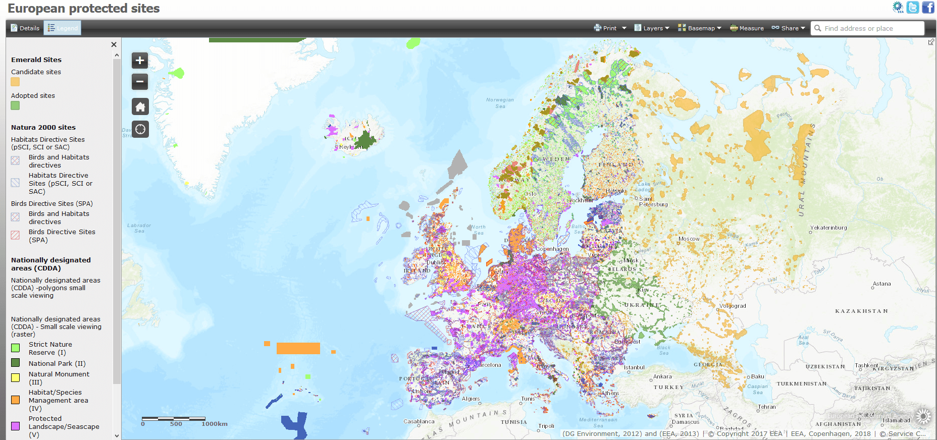
The EEA collects and displays through an online web mapping service data on European protected areas (Figure 10), covering Natura 2000 and nationally designated areas.
At global level, the World Database on Protected Areas (WDPA) is the most comprehensive global database on protected areas. It is a joint project between the United Nations Environment Programme (UNEP) and the International Union for Conservation of Nature (IUCN). Protected Planet is the online interface for the WDPA, which is also fed by text descriptions from Wikipedia.
RMIS related sections
Land use-related projects
- Minatura 2020
- Mineral Policy Guide (MIN-GUIDE) project
- Mineral Resources in sustainable land-use planning (MinLand) project
- Legal framework for mineral extraction and permitting procedures for exploration and exploitation in the EU (Minlex study)